
Gough Buildings 9
The Southern section
Detail from
First Edition
25 inch
Ordnance Survey
map dated 1877
Powys
County Archives
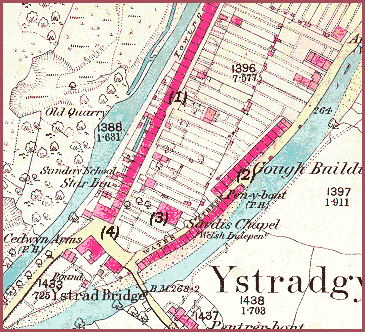
The old photographs
on this page
are from the
collection of
the late
John Morris
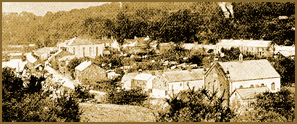
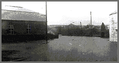 (2) The riverside position gave its name
to this row of houses on the edge of the Tawe. The weirs built
along the river to put its waters to industrial use contributed
to regular flooding of the street at times of high water and
the row was demolished. This photograph shows a typical flood
at the southern end of what was once known as Water Street.
(2) The riverside position gave its name
to this row of houses on the edge of the Tawe. The weirs built
along the river to put its waters to industrial use contributed
to regular flooding of the street at times of high water and
the row was demolished. This photograph shows a typical flood
at the southern end of what was once known as Water Street.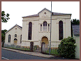 (3) Sardis Chapel was first sited
further north on the island of old Ystradgynlais but was forced
to relocate by subsidence from the old workings of Pwll bach
Cwmgiedd. (see Gough Buildings 3).
The congregation managed to get by on a temporary basis in premises
in Penybont Row and Gough Buildings (Rhestr Fawr). Residents
in this latter street offered parts of their garden plots for
a site for a new chapel and so a fine new chapel was built on
the premises in 1861 using materials where possible from the
old Chapel.
(3) Sardis Chapel was first sited
further north on the island of old Ystradgynlais but was forced
to relocate by subsidence from the old workings of Pwll bach
Cwmgiedd. (see Gough Buildings 3).
The congregation managed to get by on a temporary basis in premises
in Penybont Row and Gough Buildings (Rhestr Fawr). Residents
in this latter street offered parts of their garden plots for
a site for a new chapel and so a fine new chapel was built on
the premises in 1861 using materials where possible from the
old Chapel.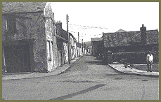 (4) The Square, Ystradgynlais, fronted
by the Ynyscedwyn Arms, was the heart of the community during
the victorian period and shops developed around it. The Square
was also a natural gathering place for open air meetings and
protests. This photograph from the 1950's shows the old Shop
yr Oen fronting onto the Suare from the end of Gough Buildings
(Rhestr Fawr).
(4) The Square, Ystradgynlais, fronted
by the Ynyscedwyn Arms, was the heart of the community during
the victorian period and shops developed around it. The Square
was also a natural gathering place for open air meetings and
protests. This photograph from the 1950's shows the old Shop
yr Oen fronting onto the Suare from the end of Gough Buildings
(Rhestr Fawr).