The huge area of hills and valleys
taken over by Birmingham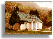 City Council for their water supply was very thinly populated, but many
lives were changed by the project.
City Council for their water supply was very thinly populated, but many
lives were changed by the project.
A church, a chapel, a schoolhouse,
and 18 cottages and farmhouses were lost because of the plans to flood
the Elan and Claerwen valleys.
The little community of Nantgwyllt was at the bottom of the flooded valley
near the meeting of the Rivers Elan and Claerwen.

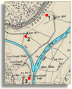 The
site of the lost Nantgwyllt church,
seen above on an old postcard, is now at the bottom of Caban-coch reservoir.
The famous poet Shelley visited this church in 1811, when he was staying
nearby. The church was at the spot marked 1
on this section of a 1905 map. Although the valley was flooded by 1905,
the map shows the construction stage of the scheme.
The
site of the lost Nantgwyllt church,
seen above on an old postcard, is now at the bottom of Caban-coch reservoir.
The famous poet Shelley visited this church in 1811, when he was staying
nearby. The church was at the spot marked 1
on this section of a 1905 map. Although the valley was flooded by 1905,
the map shows the construction stage of the scheme.