| Map of the Elan Valley dams | ||
|
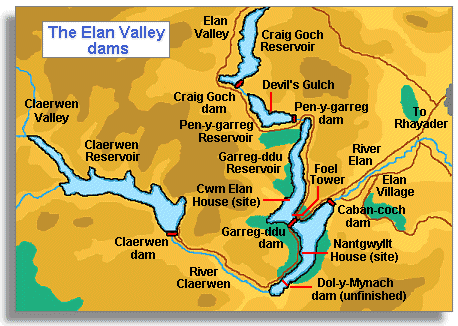
The map
on this page shows the location of the dams and reservoirs built in the
Elan and Claerwen valleys of mid-Wales at the end of the Victorian years.
The Claerwen dam, which is also marked on the map, was built much later
and opened in 1952. |
|
||
|
The area shown on this sketch map covers about 9 miles from west to east and about six and a half miles from north to south. The amount of land bought by the Birmingham authorities for the scheme was bigger than this because they needed control over all the small rivers and streams (called tributaries) which flowed into the two main rivers. This larger area is called the watershed.
|
||
|
RDR
|