Hay and the Wye valley
Victorian maps
  Llyswen around 1840  
 

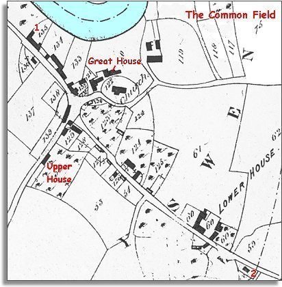
The map below is based on the early Victorian tithe map. It gives us a picture of the community as it was at this time. The Common Field in the top right hand corner is a large open field system with land shared out in narrow strips. This is a system introduced in the medieval period and it is unusual to find it still in use at this time. Find out more by visiting the pages called A Common Field.


TITHE MAPS
In Victorian times almost everyone had to pay tithes to the Church of England. At the beginning of the reign the tithe became a tax on your property. The maps were drawn to see what property everybody had.
Llyswen around 1840
  The village itself had probably not changed much since the 18th century. You can see at a glance it grew up where two important routeways meet.
Going from the top left to bottom right is the Wye valley route from Builth down into England with a road branching off to Talgarth and South East Wales. Branching off from this in the middle of the village is the road over the hills to the Usk valley and Brecon.
Just off the map to the North is the crossing point over the river at Boughrood Bridge.
 
  1 The large building which became The Royal Oak pub was a group of three cottages and gardens at the beginning of Victoria's reign.  
  2 Right on the parish boundary stands the Calvinistic Methodist chapel. This allowed local methodists to worship in their own way and choose their own ministers. They still had to pay tithes to the Church of England though.
How do you think they would feel about that?


Compare with Llyswen in 1887...
Back to the Hay maps menu
.

Back to top
Go to Hay menu