The 1840
tithe map for the parish of Llyswen
reveals something unusual. The map shows a large area of narrow strip
fields, and the records which go with the map call this area the "Common
Field".
In medieval times arable land was divided up into narrow strips and divided
up between the villagers. Each villager got the same number of strips,
and these were spread out so that everyone got a share of the better and
poorer land. Villagers could also graze their animals on the open common
pasture.
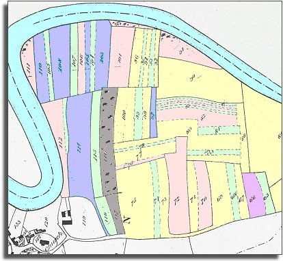
The map below shows this ancient system still in use in 1840 in Llyswen.
We have coloured in the strips so you can see who held what land. The
table underneath gives the names.

TITHE MAPS
In Victorian times almost everyone had to pay tithes to the Church of England. At the beginning of the reign the tithe became a tax on your property. The maps were drawn to see what property everybody had.