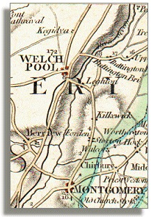
Montgomeryshire Canal
Transport
  A canal link to Welshpool and beyond  
 

The 16 mile (25km) stretch of the Montgomeryshire Canal from Llanymynech to Garthmyl was built between 1794 and 1797, opening just 40 years before Victoria became Queen.
The canal builders had planned to continue as far as Newtown but could not raise enough money at the time, so the route had a canal port at Garthmyl almost by accident.
The map shown below follows on southwards from the section showing the link to the Ellesmere Canal on the last page.

This 'middle section' of the Montgomeryshire Canal became known as the "Eastern Branch", and the final section southwards to Newtown was the "Western Branch".
The canal
on a map
of 1794
(right)
Map of route,1794
The uneven line on the map just to the right of the canal is the River Severn. The canal route can be seen passing close to Welshpool and Berriew as it continues south-west towards Newtown.
 

The canal is the
black line coming
down from
top right to
bottom left on
this map.

Canal wharf
at Welshpool
(far right)

Canal wharf at Welshpool

Although it is often now called the Montgomery Canal it was not close to the town of Montgomery, as this map shows.
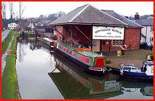
The Canal Wharf at Welshpool, seen in the recent photograph above, was the operating centre of the whole canal. The row of white "cottages" on the right included the canal office, a salt warehouse, a joiner's workshop, and the lock-keeper's cottage.
The large warehouse at the centre is now the Powysland Museum.
The Town Lock can be seen further down the canal. There used to be a corn-mill with a water-wheel next to the lock, which can be seen in an earlier photograph in this section.

Back to Montgomeryshire Canal menu


Back to top
Go to Welshpool menu
RDR