Montgomeryshire Canal
Transport
  The northern link with the Ellesmere Canal  
 

The northern section of the Montgomeryshire Canal was the first to be built. This was really a branch of the Ellesmere Canal (later to be known as the Llangollen Canal) over the English border in Shropshire, which was part of the 'main line' canal network.
It was constructed to provide a transport link to the limestone quarries at Llanymynech.


Montgomery
Canal route
on a map
of 1794

The
Ellesmere Canal
is the black line
at the top right
corner of the map

The
Montgomeryshire

Canal is the black
line running down
the middle to
Llanymynech and
beyond

Part of 1794 map This is part of a map of 1794, which included existing and planned canals.
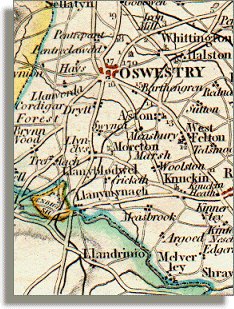
It shows the canal branch from the Ellesmere (Llangollen) Canal at the top right down to the quarries at Llanymynach, and then off the bottom of the map towards Welshpool and beyond.
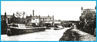
The canal at Llanymynech around 1910
Canal at Llanymynech
 

This map was published by John Cary "Engraver and Map-seller" in London in June 1794. It showed the routes of several canals which had not been built by then but were laid out on plans for approval by Parliament.
These proposed waterways "were inserted at the request of many gentlemen who are interested in those canals".
The entire route of what was later to become known as the Montgomeryshire Canal was thus shown on this map even though the southernmost or "Western Branch" of the canal to Newtown did not open until 1821, some 27 years after the map was published.

Back to Montgomeryshire Canal menu


Back to top
Go to Welshpool menu
RDR