
TITHE MAPS
In Victorian times almost everyone had to pay tithes to the Church of England. At the beginning of the reign the tithe became a tax on your property. The maps were drawn to see what property everybody had
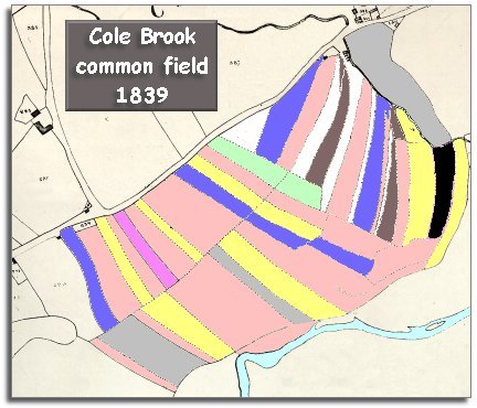
| An ancient field system in Victorian Bronllys | ||
|
The 1839
tithe map for the parish of Bronllys reveals something unusual.
The map shows a large area of narrow strip fields, and the records which
go with the map call this area the "Cole Brook
Common Field". |
|
TITHE MAPS In Victorian times almost everyone had to pay tithes to the Church of England. At the beginning of the reign the tithe became a tax on your property. The maps were drawn to see what property everybody had |
|
|
|
||
|
All the above above people apart from William Williams rented this land from a landowner. Mr Prosser of Porthamal rented his farm and these strips from the Earl of Ashburnham for example. Evan Davies rented his land from Colonel Woods who was a local landowner and M.P. for the county. More about the Common field at Bronllys...
|
|
|