 The
relief map to the right shows us the lower lands
in the angle between two mountain ranges. To the right of the map you
can see the high ridges of the Black Mountains and off the map to the
south-west lie the Brecon Beacons.
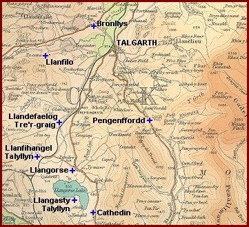
The
relief map to the right shows us the lower lands
in the angle between two mountain ranges. To the right of the map you
can see the high ridges of the Black Mountains and off the map to the
south-west lie the Brecon Beacons.
This area of lower lands is still an agricultural area today, and in Victorian times an even bigger proportion of local people earned their living by working on the land in some way.
This gap between the upland areas became an important route for local transport in Victorian times.
Like the other areas on our website, Talgarth and the other communities in this part of Breconshire underwent great changes during Queen Victoria's reign.
Choose from
the topics below to
explore some of these changes:
.