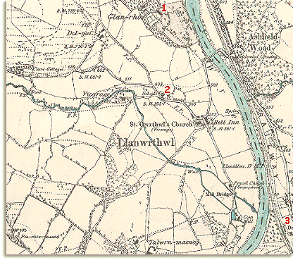
This map was made by the Ordnance Survey in 1891. By comparing this map with the 1847 tithe map of Llanwrthwl you will be able to see some of the changes that came to the area in the Victorian period.
| Llanwrthwl in 1891 | ||
|
This map was made by the Ordnance Survey in 1891. By comparing this map with the 1847 tithe map of Llanwrthwl you will be able to see some of the changes that came to the area in the Victorian period. |
||
|
||
| 1. A grand new house called Glan-Rhos has been built to the north of the village, and surrounding grounds laid out stretching down to the river. | ||
| 2. The village now has a school. This was very important for local poor families. Their children could learn to read and write, which would give them other opportunities when they left. (See the section on Victorian School Days for more about school life in the area). | ||
|
3. Running down the Wye valley on the Radnorshire bank is the Mid Wales Railway. The nearest station to Llanwrthwl was Doldowlod station, just across the river from the corn mill. The new railway opened in 1864 and improved communications enormously. Compare
with Llanwrthwl in 1847... |
|
|
|
|