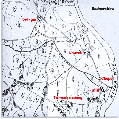
The map shows the small hamlet of Llanwrthwl around St. Gwrthwl's church and the eastern part of the parish in the banks of the River Wye. This formed the border between Breconshire and Radnorshire.

| Llanwrthwl in 1847 | ||
| The map below
is based on the tithe map of around
1847. It was made by the church authorities
for tax purposes. The men who made it did not put north at the top, so we
have turned it to make it easier to compare with the later map of Llanwrthwl.
This is why the old writing on the map is at an angle. The map shows the small hamlet of Llanwrthwl around St. Gwrthwl's church and the eastern part of the parish in the banks of the River Wye. This formed the border between Breconshire and Radnorshire. |
||
 |
||
| Much of the parish of Llanwrthwl is wild mountainous land, but in the valleys of the rivers Elan and Wye the soils are kinder and there are larger farms like Talwrn-maenog and Dol-gai. | ||
| Notice
on the road coming south from the village a water
mill near the river. In Victorian times the water mill was an
important feature of the landscape.
Water power could be used in woollen mills to drive looms or for treating
the cloth with a chemical called Fuller's Earth to clean it. This mill was a corn mill where local farmers took their grain to be ground into flour. |
||
|
Notice also that in 1847 there was a chapel on the same road, so that local people had a choice of the local parish church or an independent chapel where the members organised their own worship and appointed their own ministers. Compare
with Llanwrthwl in 1891... |
|
|
||