![]() |
![]() |
||||||||||
|
|||||||||||
Rhayader Victorian Maps |
Rhayader in 1904 | ||
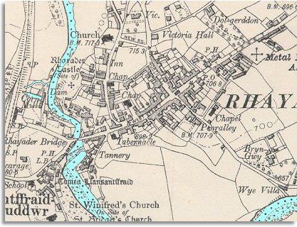
The map below is taken from a detailed
Ordnance Survey map made in 1904. |
||
![]() |
There are more buildings in West Street and Church Street and it is obvious the town has developed and grown. Look at the Rhayader population graph to see what changes there were in the number of people in the town. | ||
Across the bridge in Cwmdeuddwr - on the western edge of the map - stands Rhayader station which has improved the area's communications with the outside world and offered opportunities to travel for working people. Compare with
Rhayader in 1840... |
|
||