Llanfair and district
Victorian maps
  Castle Caereinion in 1836  
 

The map below is an enlarged section of an Ordnance Survey map made at a scale of 1 inch = 1 mile in 1836. Although it is not very detailed it does give us an idea of the area in the early Victorian period.
The way the map is shaded gives us a very good idea of the shape of the landscape. From this you can see that the tiny hamlet has developed on a rise where roads meet.
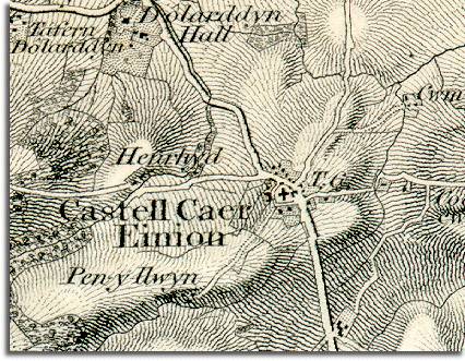
 
 
  Notice how few houses there are in the map. It is obvious that this is a sparsely populated rural area. (Visit the population graph for the parish to see what the population was in Victorian times.)  
  You can see Dolarddyn Hall and its grounds on the map. The grounds are bigger than the hamlet itself. This gives us some idea of the tremendous difference in wealth in Victorian times between the landowners and the families who worked for them.  
 

Marked T.G. on the map is a tollgate. This is where anyone travelling with an animal would have to pay to use the next section of road. (To find out more about tollgates and turnpike roads visit the Transport section under Topics)

Compare with Castle Caereinion in 1902


Back to the Llanfair maps menu

Back to top
Go to Llanfair Caereinion menu