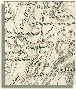
Llandrindod
in 1833
(far right)
in 1833
(far right)
As you can see from the map portion
shown here, and from the map pages on this
part of our website, there were only a few isolated farmhouses and other
buildings in the area in 1833.
But there were two linked developments
which were later to make a huge difference. The enclosure
of the large expanse of Llandrindod Common in 1862,
mainly to the benefit of wealthy local landowners, was very important.
With the opening of the railway just
three years later, they and others were quick to see the possibility of
making money from the development of the area after it had become so much
easier to reach.
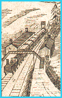 first
section of the Central Wales Line from Knighton to Llandrindod was opened
in 1865, and the whole line from Shrewsbury
to Swansea was completed in 1868.
This made it easy for visitors to come to Llandrindod in large numbers
from the industrial areas of northern England, from the Midlands, and
from South Wales.
first
section of the Central Wales Line from Knighton to Llandrindod was opened
in 1865, and the whole line from Shrewsbury
to Swansea was completed in 1868.
This made it easy for visitors to come to Llandrindod in large numbers
from the industrial areas of northern England, from the Midlands, and
from South Wales.