| Stanage in 1833 | ||
|
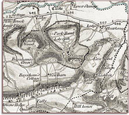
Below is a small part of a larger
map made by the surveyors of the Ordnance Survey
in 1833 and sold in bookshops. It
was made at a scale of 1 inch = 1
mile and we have enlarged it here. |
|
|
|
|
| The map shows the importance of Stanage Park in the community. The Park occupies a large portion of the parish and we can see the deer fence running round it. Many of the other farms marked here would have belonged to the Stanage estate. | ||
|
The 1841
census gives some idea of who was living and working here in these early
Victorian years. Again we can see the importance of the Rogers family
of Stanage. Many of those living nearby had a connection to the estate.
|
||
|
|
|
|