Knighton
and district
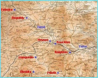 The
small Welsh market town of Knighton
stands on the English border where the River Teme flows into England.
The
small Welsh market town of Knighton
stands on the English border where the River Teme flows into England.
Built originally as
a controlled crossing place on Offa's dyke, the town always looked eastward
and had good links with Shropshire and Herefordshire.
Victorian Knighton had long been a centre for the farming
community with its livestock sales and transport links.
Like the other communities on our website, Knighton and the villages of north-eastern Radnorshire underwent great changes during Queen Victoria's reign.
Choose from
the topics below to
explore some of these changes:
.