
TITHE MAPS
In Victorian times almost everyone had to pay tithes to the Church of England. At the beginning of the reign the tithe became a tax on your property. The maps were drawn to see what property everybody had
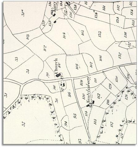
| Heyope around 1840 | ||
|
The map below is based on the tithe
map of the 1840s and it
gives us an idea of the hamlet of Heyope
in the early Victorian period. |
|
TITHE MAPS In Victorian times almost everyone had to pay tithes to the Church of England. At the beginning of the reign the tithe became a tax on your property. The maps were drawn to see what property everybody had |
|
|
| Despite the
fact that Heyope was a tiny scattered community, it had its own crafts and
services. Besides the farmers and farm
workers, there were stonemasons and other craftsmen. At the house known as the Corner were Martha Morgan (25) and her elderly parents. Her father Samuel Morgan still lived a hard life as a farm worker at 70. Martha made a living as a dressmaker and a young tailor lived and worked with them. There was also a dressmaker at Church House. |
||
| Compare with Heyope in 1903... | ||
|
|
|
|