
TITHE MAPS
In Victorian times almost everyone had to pay tithes to the Church of England. At the beginning of the reign the tithe became a tax on your property. The maps were drawn to see what property everybody had
| Llangynllo around 1840 | ||
|
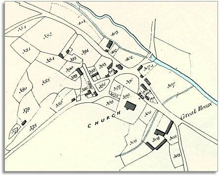
The map below is based on the tithe map of around 1840 and gives us an idea of the village of Llangynllo in the early Victorian period. From the map we can see that this small community developed at a convenient crossing point over the River Lugg. |
|
TITHE MAPS In Victorian times almost everyone had to pay tithes to the Church of England. At the beginning of the reign the tithe became a tax on your property. The maps were drawn to see what property everybody had |
|
|
| The census returns for 1841 tell us who lived and worked here around that time. Even this small village had a full range of craftsmen working in it. There were 4 wheelwrights, a mason, a carpenter, a blacksmith and a sawyer. There were also 4 shoemakers to supply the needs of local people ! | ||
|
The village inn was run by Edward Davies aged 27, and the census indicates that there must have been a school of sorts because a schoolmaster, Samuel Morgan aged 65, was living there. |
||
|
|
|
|