
TITHE MAPS
In Victorian times almost everyone had to pay tithes to the Church of England. At the beginning of the reign the tithe became a tax on your property. The maps were drawn to see what property everybody had
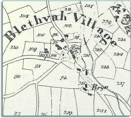
| Bleddfa around 1840 | ||
|
The map below is based on the tithe
map of around 1840, and it gives us
an idea of the hamlet of Bleddfa in the early
part of Queen Victoria's reign. |
|
TITHE MAPS In Victorian times almost everyone had to pay tithes to the Church of England. At the beginning of the reign the tithe became a tax on your property. The maps were drawn to see what property everybody had |
|
|
| The
census returns for 1841 tell us who
lived and worked here around that time. Even this small parish was a thriving
community. Most of the inhabitants were farm labourers,
but there were others earning a living in other ways. There were 2 shoemakers and 2 carpenters. At the mill in the village lived the miller John Evans with his young wife and child. The Old Hundred House Inn was run by publican Richard Hamer, who had an engineer lodging there at the time. |
||
|
A mystery! Mystery
solved! |
||
Compare with Bleddfa in 1903... |
||
|
|
|
|