The image below is based on the tithe map for the parish of Llowes. It shows the area around the village itself and gives us an impression of the community in the first years of Queen Victoria's reign.

TITHE MAPS
In Victorian times almost everyone had to pay tithes to the Church of England. At the beginning of the reign the tithe became a tax on your property. The maps were drawn to see what property everybody had.
 The
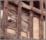
last was a Thomas Jones and his job was to split wood into long thin,
flat pieces. These were used in building timbered
cottages. They could be woven across the gaps in a timber frame
and then plastered over. This picture of the ruins of the old Three Tuns
inn in Hay shows the laths in the frame of the building.
The
last was a Thomas Jones and his job was to split wood into long thin,
flat pieces. These were used in building timbered
cottages. They could be woven across the gaps in a timber frame
and then plastered over. This picture of the ruins of the old Three Tuns
inn in Hay shows the laths in the frame of the building.