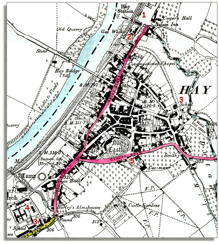
The image below is based on an Ordnance Survey map published in 1887 at a scale of 6 miles = 1 inch. By comparing it with the map of Hay around 1836 we can see some of the changes which have occurred.
| Hay in 1887 | ||
|
The image below is based on an Ordnance Survey map published in 1887 at a scale of 6 miles = 1 inch. By comparing it with the map of Hay around 1836 we can see some of the changes which have occurred. |
||
|
|
|
|
| 1. The railway has come to Hay. This meant much improved communications with parts of the country further afield. (See pages on the coming of the railway for more information). These improved communications helped the town to develop as a market. See the population graph for Hay to see the effect of this. | ||
| 2. The town now has a gas works making coal gas which is then piped into houses as gas is today. This was used mainly for gas lighting but some houses may have had a gas cooker by this time. Many of the cottages of the ordinary workers would still have been lit by candles and rush lights in 1887. | ||
| 3. Although there were schools in Hay at the beginning of Victoria's reign the map above shows two new schools. One is at the bottom of the map near the workhouse, and the other built up against the old eastern wall of the town. In 1887 all local children had to attend school and this was having an effect on the lives of local people. (For more detail on this see the pages on Victorian school days) | ||
| 4. The Hay Poor Law Union was created in the 1830s and a workhouse built on the edge of the town to house those poor people who could not maintain themselves. They were usually people too old or ill to work, or families abandoned by the father or who had lost the father through illness. The Hay Union covered a large area of Breconshire and southern Radnorshire. | ||
|
5. The 1836 map showed no buildings south of Oxford Road, but we can see the first houses built here among the orchards on the South side of the town. The large orchard to the South of the castle is today a car park. |