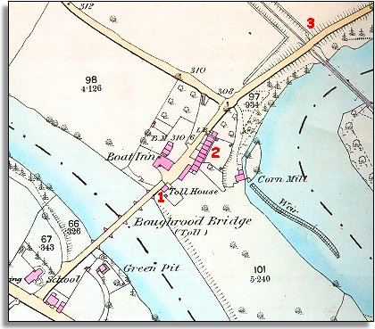
The map below is based on the large scale Ordnance Survey map of the area made in 1887. The detail of the map shows some of the changes that have come to the spot since 1840.
| Boughrood Bridge in 1887 | ||
|
The map below is based on the large scale Ordnance Survey map of the area made in 1887. The detail of the map shows some of the changes that have come to the spot since 1840. |
||
|
|
|
|
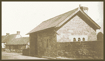 1.
A Toll House stands on the Radnorshire
bank of the river. This was built sometime in the 1840s to house the toll
keeper who charged people a small fee for crossing the over the bridge.
A trade directory of 1875 lists the toll collector who lived in the tiny
house as James Portnell. 1.
A Toll House stands on the Radnorshire
bank of the river. This was built sometime in the 1840s to house the toll
keeper who charged people a small fee for crossing the over the bridge.
A trade directory of 1875 lists the toll collector who lived in the tiny
house as James Portnell. |
||
| 2. More cottages have been built in the little community by the bridge. The trade directory of 1875 lists a shoemaker and a shopkeeper and the Boat Inn is run by Mrs Sarah Fowler. | ||
|
3. Perhaps the biggest change to the area is the coming of the railway. This put this tiny community within easy reach of far off towns, cities and markets for those who could afford it. The tiny Boughrood station is just off the map to the North. In 1875 the station master was Mr H. Blayney. |