| |
1.
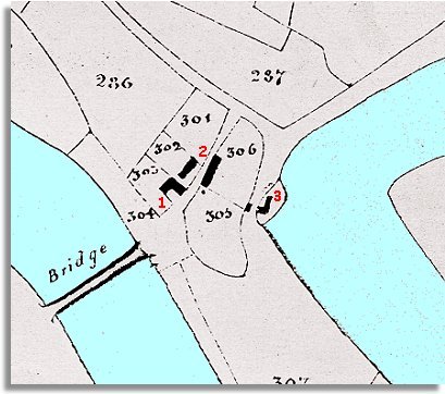
The site of The Boat Inn. Like most
of this community it was owned by the De Winton family of Maesllwch. On
the 1841 census the inn was run by Lydia Pryse. At this time when most travellers
went by coach, horseback, or on foot, journeys took much longer. Inns at
key points like bridges or junctions (Griffin Inn, Llyswen) offered overnight
accommodation. |
|
| |
2.
On either side of the road we can see a cluster of cottages listed as Boatside
cottages at the time. On the left hand side of the road (West)
lived a surveyor Charles Fowke and his wife and 6 children. As a surveyor
he may have helped in the drawing up of these tithe maps.
In the other cottages were various other families including a shopkeeper
and a tailor. |
|
| |
3.
On the banks of the River Wye we see Boughrood
Mill. This was a corn mill grinding local corn into flour run
by William Davies the miller. This was a vital process throughout the
Victorian period when every community had its mill and some had several.
Compare
with a map of the bridge in 1887...
|
|