| |
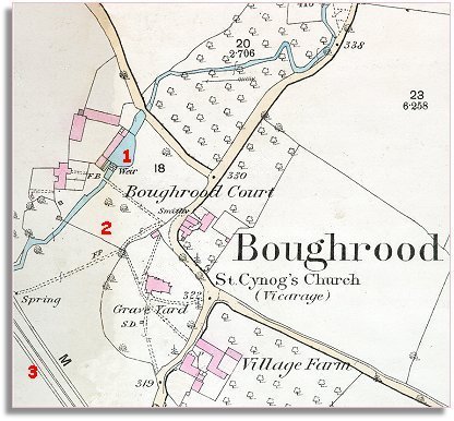
1
The stream past Boughrood Court has had
a weir added creating a pool by the outbuildings. Perhaps this was used
to power a mill on the site. |
|
| |
2
The earlier Tithe Map shows a lane going right around the church yard with
a house on the North Western side. This 1887 map shows the road only now
going on the Eastern side of the churchyard, and the house appears to have
gone completely! |
|
| |
3
The biggest change of all to the area is the coming of the
railway. Here you can just see a small section of the Mid Wales
railway passing through the corner of the map. There was a tiny station
just below the village which meant local people could go by train up through
Builth, Rhayader and Llanidloes into Mid Wales, or travel down the line
to Brecon, or off into England and the great network of railways across
Victorian Britain.
. |
|
| |
Compare
with the map of Boughrood in 1840 |
|