| |
1.
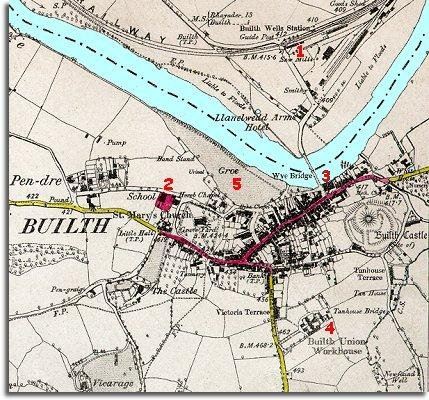
The railway
has come to Builth (even if Builth station is in Llanelwedd!). This connected
the town and surrounding area with a great railway network which made travel
across the country and the transporting of goods much easier. It also allowed
Builth (and Llangamarch and Llanwrtyd) to attract visitors to take the mineral
waters and develop as a spa town. (See pages on transport) |
|
| |
2.
A school has been set up for the ordinary
children of the town. This was very important as the children were taught
to read and given other skills which meant there were better
employment opportunities for them when they grew up. (See pages
on school life). |
|
| |
3.
Where in 1840 there was an empty square at the end of the bridge, the map
here shows the new grand Market Hall
which was built in 1877. This is now the Wyeside Arts Centre. |
|
| |
4.
To the south of the town the Builth Poor Law Union has built a large new
workhouse to house the poor of the district who
could not support themselves. Here they were locked away until they had
some means to earn money outside in the community. It was built in 1877
and demolished in 1941. (See pages on Care of the Poor) |
|
| |
5.
The old water course which cut off the Gro from the town has been filled
in and the Gro has become a park with a band stand.
This is part of the towns efforts to attract new visitors to holiday there
and take the waters. Notice also across the road to the South, The Strand
has been built right through to High Street and the Strand Hall built. |
|
