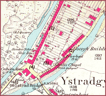
Ystradgynlais This
1877 map shows the layout of the
streets on the southern end of the "island"
of old Ystradgynlais. They have not changed that much from the layout
indicated on the 1837 map. (see Gough
buildings 1) All the streets shown on this section
of the map used to be marked as "Gough's
Buildings" though they gradually became known under different
names. (1)
This long row of Victorian workers' houses
along the canal bank is now known as Rhetr Fawr. (2)
The tiny houses of Water Street were
built on the very edge of the river and eventually had to be demolished
as they flooded regularly. (3)
Sardis Chapel was first sited further
north but was forced to move (see Gough Buildings
3). The congregation managed to assemble for a while in houses in
Penybont Row and Gough Buildings (Rhestr Fawr). Residents gave up parts
of their gardens for a site for a new chapel, and so a fine new building
was put up by the chapel members themselves in 1861
using materials from the old chapel. (4)
The Square,
Ystradgynlais, in front of the Ynyscedwyn Arms, was the heart of the community
during the Victorian period, and shops developed around it. The Square
was also a natural gathering place for open air meetings and protests.
Back to Gough's buildings
menu
Gough's buildings
4
Water
Street and The Square
From the lowly beginnings of this row several men went on to excel in
their chosen field. Perhaps the most renowned of these was musician and
composer Dr Daniel Prothero.
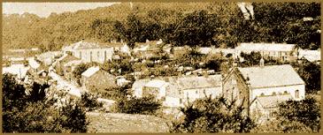
This photograph from the end of Queen
Victoria's reign shows Water Street on the far left, Sardis Chapel just
to its right, and Rhestr Fawr running across the background.