Ystradgynlais
Gough's buildings 2
  Along the canal  
 

Below is an extract from a detailed Ordnance Survey map from 1877, forty years later than the map on Gough's buildings 1.
It shows the new developments on the north end of the island. On early maps all these buildings were marked as Gough's buildings, though many have other names today.


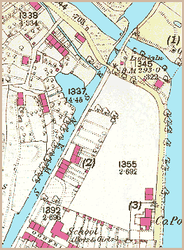
The Swansea Canal runs through the map, with a basin wide enough to turn barges around (by number 1337).
At the top of the image, a special bridge called an aqueduct carries the canal over the River Giedd. Close to this aqueduct is an old limekiln which could turn the limestone brought in barges into lime for construction, agriculture or iron forging.
(The space marked 1355 is now the site of Cynlais School.)

There are three other places marked with a number on the map -
(1) marks the location of an old coal pit already disused in 1877. The pit was called Pwll bach Cwmgiedd and its underground workings were to create problems locally. The first Sardis Chapel in Ystradgynlais, built near the canal in 1841, suffered damage due to the collapse of the old tunnels during a service in 1859, to the shock of those gathered. A new site was acquired at a safe distance.


(2) marks the double cottage now known as 5 Crown Cottages. The Crown which gave its name to these cottages is thought to have been a canalside alehouse. No 5 probably had another use around the early 19th century. It is thought that it may have been the site of the first day school in Ystradgynlais.

(3) marks the location of the Police Station and Magistrates Court built in 1857-8 to serve the expanding community. See the pages on Crime and punishment in the area to find out more about the local police.

More about Gough's Buildings...