Ystradgynlais This detail from the 1877
map shows how the Gough
family built further houses for their workers as industry in the valley
extended. You can clearly see the cottages and the garden plots which
were such an important part of community life. Other
interesting features are numbered on the map. (1)
The map shows two schools in
Oddfellows Street. The school on the bottom side of the street
was a church school established about the middle of the 19th century.
The school on the top side was a school for the children of chapel families.
By 1918 it had become divided into separate private houses and was no
longer a school. The church school was also later closed and the schoolroom
has today gone altogether. (2)
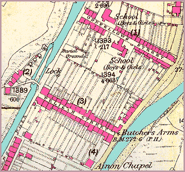
Brynygroes cottages orginally stood
by a set of locks where the canal barges went up onto the next stretch
of canal. Today the canal has gone and the houses stand at the side of
a busy by-pass (3) Like
Oddfellows Street, Pelican Street
stretched right across the "island" from
the canal to the river. At the right hand end of the street stood the
Butchers Arms. (4) Ainon
Baptist Chapel, built around 1848.
A new chapel was built on the site in 1901. Chapel members baptised their
children in the pool below Pont y Doctor up to 1925. More about Gough's
Buildings...
Gough's buildings
3
Pelican
and Oddfellows Streets
Across the road from this once stood a grocer's shop, though this has
long since gone. At the other end of the street stood a Temperance
House which refused to
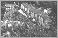
serve alcohol and where people could lodge. The picture above was taken
about 1950 but gives us an idea of what it might have been like in Victorian
times.