Montgomery
Canal route
on a map
of 1794
Canal route
on a map
of 1794
Some lime kilns and and wharf buildings were built there but it did not become a major settlement.
| The canal continues to Newtown | ||
|
The last section of the Montgomeryshire
Canal to be completed was known as the Western
Branch. |
|
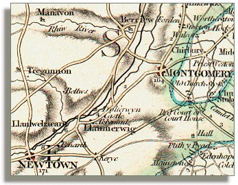
Montgomery
Canal route on a map of 1794 |
|
The original
plan was to extend the canal from Llanymynech
south-west to Newtown as a single project. But the Montgomeryshire
Canal Company ran out of
money so the canal ended at Garthmyl in 1797.
Some lime kilns and and wharf buildings were built there but it did not become a major settlement. |
|
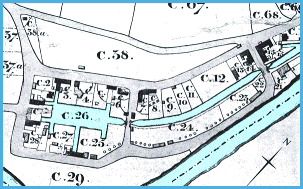
Newtown
Canal Basin on a map of 1842 (far right) |
Newtown,
at the other end of this final section of the canal, grew rapidly from
the early 1800s. The coming of the canal to Newtown in 1821
led to the building of many warehouses, wharf-houses, stables, and other
facilities connected with trade on the new canal.
|
 |
|
The 1842
tithe map above shows many of these buildings grouped around the Newtown
Canal Basin. The River
Severn is the wider blue waterway at bottom right. Back to Montgomeryshire Canal menu
|
|
|
|
RDR
|