| |
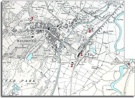
1.
The railway has come to the upper Severn
valley. The Cambrian Railway opened the line from Oswestry to Newtown via
Welshpool in 1860. This connected the
area with a network of Victorian railways stretching throughout Britain.
Where the canal had once been important
for transporting goods, now it was the railway which became the most
important means of transport.
The map shows a new gas works just to
the right of the station. Coal for the gas works was now brought in by rail. |
|
| |
2.
The County Intermediate school
stands next to the canal. It was opened in 1898
and gave local children a secondary education. In the village schools children
could leave to start work at 11, but those who were able could now go on
to the new County school. Most ordinary working families couldn't afford
it though. They needed their children to be earning a living. |
|
| |
3.
Between the canal and the railway stands the Mill Lane Foundry.
Here the furnaces made iron machinery parts. This kind of industry needs
heavy raw materials like iron ore, coal and lime, so they needed to be near
good transport links. |
|
| |
4.
There is now a bridge over
the Severn on the road to Leighton. No need for a ferry
now ! You could cross the river and keep your feet dry. |
|
| |
5.
On the 1836 map at this point is marked the depot of the local
militia. Now this base for locally recruited soldiers has been expanded.
When the local Yeomanry paraded children
came out to watch. (Click here
for an example).
. |
|
| |
Compare
with Welshpool in 1836... |
|