| |
1.
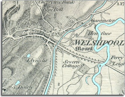
From the shape of the town you can see that Welshpool has grown up on a
cross-roads.
The main road along the Severn valley
runs from the bottom of the map to the top right corner. Another road crosses
this running from the ford on the river Severn to the left edge of the map,
where a series of smaller roads go off into the countryside.
(Notice that the ford on the Severn has a ferry
next to it to carry people and goods over the river
when the water is too deep to wade through). |
|
| |
2.
Next to the canal on the north-eastern side of the town is a sign of
modern technology coming to the area.
Here you can see the word 'Gasometer'. A
gasometer is where coal gas is stored, so there must have been a gas
works here heating coal to make the coal gas. This could then
be used for street lighting, or for lighting in the houses of the richer
inhabitants of the town. |
|
| |
3.
In the bottom left hand corner you can see Powis
Castle with its parkland, pools and gardens. The Earl of Powis
was a very important man in the area in Victorian times, as he owned property
in the town and all around the border area.
. |
|
| |
Compare
with Welshpool in 1901... |
|