Welshpool and district
Victorian maps
  Berriew in 1901  
 

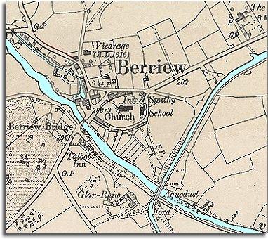
The image below is put together from a detailed Ordnance Survey map made in 1901.
It gives us a picture of the community around the end of Queen Victoria's reign, and we can see that very little has changed on the map during the long reign of Queen Victoria.

 
  There do not appear to be many new houses. The two inns which were busy in the village in 1840 are still there, as are the smithy, mill and school.
By the time this map was made all the local children would have attended the school and had an education.
 
  Although the canal is still marked on the map the lime kilns have gone. By 1901 the canal was little used and most lime would have come into the area in sacks on the railway.
(See the section on transport in the area.)
 
 
Compare with Berriew in 1840...


Back to Welshpool maps menu


Back to top
Go to Welshpool menu