Welshpool
and district
Victorian maps
Berriew in 1840 | ||
The map below is based on a section
of the tithe map for the parish of
Berriew. |
The
original map was not aligned with north at the top, so we have turned
it round to make it easier to compare with later maps.
|
|
TITHE MAPS In Victorian times almost everyone had to pay tithes to the Church of England. At the beginning of the reign the tithe became a tax on your property. The maps were drawn to see what property everyone had. |
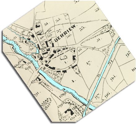
You
can see from the map that this little community grew up where the road down
the Severn valley crossed over the River Rhiw. At the heart of the village you can see the church in its churchyard, with houses around it. |
||
The
map also shows where the canal crosses
over the river. Further up the canal (where the figure
49 is marked)
you can see a row of circles marking lime kilns. The barges would bring limestone along the canal which would be heated in the kilns to produce powdered lime. This could be spread on the fields to increase fertility, or be used to make cement. |
||
The census returns for 1841 tell us who was living and working around the village at this time. There were:- 2 weavers, 1 wool spinner, 2 maltsters, 4 tailors, 2 masons and a builder, 2 carpenters and a cabinet maker, 3 blacksmiths, 2 coopers (and an apprentice), a lock keeper on the canal, a schoolmaster (Jeremiah Medlicott), a shoemaker with an assistant and an apprentice, a butcher, a saddler, a miller, a coachman and a sawyer. On a barge on the canal behind the Horeshoe Inn was 15 year old John Owen. He was one of the barge people who grew up and spent most of their lives on the great canal network. Berriew was certainly a busy community! |
||
|
||