Welshpool and district
Victorian maps
  Guilsfield in 1842  
 

The map below is based on a section of the tithe map for the parish of Guilsfield, and it gives us a good idea of the layout of the village in the early years of Queen Victoria's reign.
As you can see, each house and plot of land is numbered. We have removed some of the numbers to make it easier to see the details of the map.

The original map was not aligned with north at the top, so we have turned it round to make it easier to compare with later maps.

TITHE MAPS
In Victorian times almost everyone had to pay tithes to the Church of England. At the beginning of the reign the tithe became a tax on your property. The maps were drawn to see what property everybody had
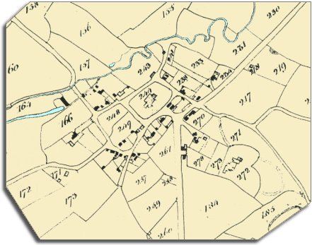
  From the map you can see that Guilsfield developed where two roads meet. From the bottom of the map you can see the road from Welshpool and the Severn valley.
From the bottom left of the map to the top right you can see the road run from the upland areas of Montgomeryshire along the valley towards England.
 
  Like Berriew, this is a thriving valley community clustered around a church. (In the upland areas people tended live in scattered farms and holdings).  
  A special branch of the Montgomeryshire Canal was built to a point outside the village just off the map to the north-east.
This was very useful to local people as heavy goods like stone, coal, bricks and lime could be brought in on barges, and farm produce could be taken to far off towns and markets.


The census returns for 1841 tell us who was living and working around the village at this time. There were:-

3 shoemakers, 3 butchers, 3 publicans, 2 masons, 2 wheelwrights, 2 tailors (and an apprentice), 2 smithies, 2 millers (you can see Guilsfield mill and its pond at top left), 1 grocer, 1 carpenter (aged 70), 1 schoolmaster (John Roberts), 1 weaver, 1 cattle dealer, and a beadle (Richard Owen 65).

The beadle was an official of the parish. He would deal with minor problems like farmers not fencing their animals in properly, or the removal of poor people from one parish to another.


Compare with Guilsfield in 1901...


Back to Welshpool maps menu


Back to top
Go to Welshpool menu