Talgarth and district
Victorian maps
  Talgarth in 1841  
 

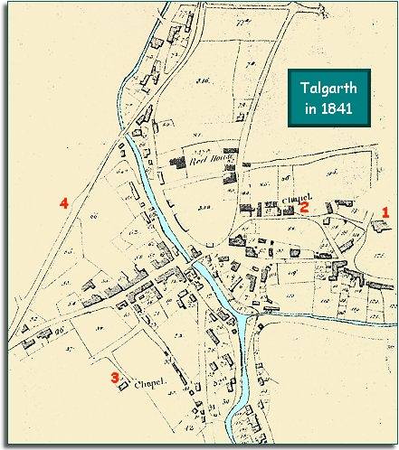
The map below is based on a section of the tithe map for the parish of Talgarth, and it gives us a good idea of the layout of the town in the early years of Queen Victoria's reign.
We can see that at this time the town was a thriving community with streets and shops


TITHE MAPS
In Victorian times almost everyone had to pay tithes to the Church of England. At the beginning of the reign the tithe became a tax on your property. The maps were drawn to see what property everybody had
  1. On a rise to the east of the town centre is St Gwendoline's church and its churchyard.  
  2. Not far from the church stands a Methodist Chapel.  
  3. On the southern fringe of the town is a Congregational Chapel. These two chapels allowed local people to worship in small communities they set up for themselves.  
 

4. Along the western edge of the town runs the tramway. This early horse-drawn railway was important for local trade and farming. (See the pages on Transport for more details).

Compare with the town in 1887...


Back to Talgarth maps menu

Link to sources
Back to top
Go to Talgarth menu