Talgarth and district
Victorian maps
  Llangasty Talyllyn in 1841  
 

The map below is based on the tithe map for the parish of Llangasty Talyllyn.
It gives us a good idea of the layout of the village in the early years of Queen Victoria's reign.

The original map was not aligned with north at the top, so we have turned it round to make it easier to compare with later maps.

TITHE MAPS
In Victorian times almost everyone had to pay tithes to the Church of England. At the beginning of the reign the tithe became a tax on your property. The maps were drawn to see what property everybody had
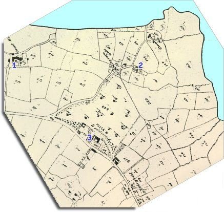
  1. The large property marked here as "Great House" is more properly known by its Welsh name Ty Mawr. At the time this map was made Rees Perrott lived there with his family and 5 servants.  
  2. At Llan at this time lived John Williams and his wife with 4 servants.  
  3. At Treberfedd House (marked here as "Treberfedd Villa") at this time lived Joseph Cooper, James Freeman, and Frederick Evans. The 1841 Census lists them all as "Independent". This means that they did not have to do a job for a living but had wealth of their own to live on, with 4 servants and a gamekeeper to look after them.  
 

Most of the local population of the parish were farm labourers on these and other farms, but there were also 3 carpenters busy in the area.

Compare with Llangasty in 1887...


Back to Talgarth maps menu

Link to sources
Back to top
Go to Talgarth menu