This image is taken from an Ordnance
Survey map first surveyed in 1833.
It gives us an excellent picture of the landscape
of the Elan Valley at the very
beginning of Queen Victoria's reign.
The way the map is shaded lets us see the twisting course of the river
and the steep hills to either side.
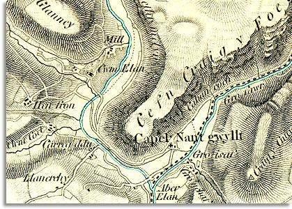
 The
grand house marked Cwm Elan can be seen
on the west bank of the river, standing in its own grounds. For a short
while this had been the home of the great poet Shelley.
The
grand house marked Cwm Elan can be seen
on the west bank of the river, standing in its own grounds. For a short
while this had been the home of the great poet Shelley.