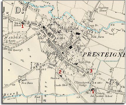
The map below is a section of a map
made at a scale of 6 inches to
1 mile in 1901.
The map shows some of the changes which have come to the town during the
long reign of Queen Victoria.
| Presteigne in 1904 | ||
|
The map below is a section of a map
made at a scale of 6 inches to
1 mile in 1901. |
||
|
| 1.
Although there were schools in Presteigne in 1835,
by the end of Queen Victoria's reign all children
received an education and had to go to school. This began to offer children
better opportunities at work when they left school. (see
Schools pages). The school in Scottleton Street (top left) was the National School. The school by Clatterbrook Bridge is the new building for what is now John Beddoes School. On this site in 1835 stood the County Gaol. (To see a photograph of the school being built click here). |
||
| 2. The railway has come to Presteigne, connecting the town to the great Victorian railway network. This would help local farmers and tradesmen sell their products further away, but the railway also brought in cheaper products from outside which could put some local craftsmen out of business. | ||
|
3. A gas works stands at the edge of town. Coal could be brought in on the railway and heated in great ovens to produce coal gas. This was then piped to houses and other buildings for lighting and cooking. |
|
|
|
|