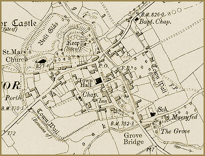
This map shows New Radnor at the
end of Queen Victoria’s reign. It shows an enlarged section
of the 6 inches to
1 mile map made by the Ordnance Survey.
Although Victoria’s reign brought many changes to the area, the basic
shape and size of the community have not changed much since 1835. There
are some changes however.
As well as the old church there are two chapels
in the village. (Marked Bapt.
Chap. [Baptist]
and Chap.)
This shows that there were new forms of Christian worship in the
area.
P.O. on
the map indicates a Post Office. Letter
writing became increasingly popular as more people were able to read,
thanks to the new schools.
The New Radnor School is marked Sch.
on the map. To see what school life was like visit the Schools
pages.
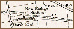 One
of the most imortant changes to the community is too far out to be included
in the image. Half a mile from the centre of the village stood the tiny
New Radnor station connecting the
community to the rail network. (See transport pages
on the railway).
One
of the most imortant changes to the community is too far out to be included
in the image. Half a mile from the centre of the village stood the tiny
New Radnor station connecting the
community to the rail network. (See transport pages
on the railway).