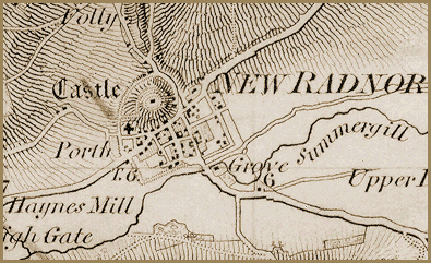
This image is an enlarged section
of a 1inch to
1 mile map published by the Ordnance Survey in
1835. It shows New Radnor at the time Queen Victoria came
to the throne.
The shape of the community is still that of the medieval borough created
centuries before. The castle, now
ruined, still stands on the mound to the north of the town. Many of the
houses standing in 1835 had been built of stone taken from the castle.
The letters T.G. to the west of the
village denote the Tollgate.