| Llanwrtyd Wells in 1887 | ||
|
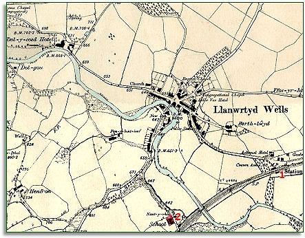
The map below is a section of a map
made at a scale of 6 inches to
1 mile in 1902. Like the
tithe map, it shows the river crossing and the surrounding area. |
|
|
|
|
| 1. The development which allowed all these changes to happen is the coming of the railway in the 1860s. Like Llandrindod and Builth, Llanwrtyd grew quickly once the railway allowed visitors to reach the area much more quickly and comfortably. (Visit the section on the spas of the area to find out more). | ||
|
2.
The map above also shows that
the area has a new school by the railway.
By the end of Queen Victoria's reign all the local children would have
had an education up to 13. |
||
| Compare with a map of the area around 1845... | ||
|
|
||