
TITHE MAPS
In Victorian times almost everyone had to pay tithes to the Church of England. At the beginning of the reign the tithe became a tax on your property. The maps were drawn to see what property everybody had.
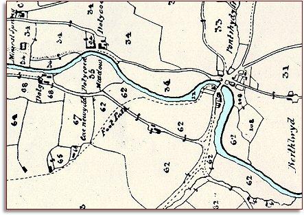
| "Pontrhydyfferau" around 1845 | ||
|
If you look on the tithe
map for the parish of Llanwrtyd you will not find a place called
Llanwrtyd Wells. It didn't exist then. Instead, at the point where the
road crosses the river Irfon, you will find the tiny hamlet of Pontrhydyfferau
(or Pontrhydyferi as it is sometimes
spelled). |
|
TITHE MAPS In Victorian times almost everyone had to pay tithes to the Church of England. At the beginning of the reign the tithe became a tax on your property. The maps were drawn to see what property everybody had. |
|
|
|
The surveyors who made the map had
to fit it onto a large sheet, so they turned it round to make it fit.
We have shown it here with North at the top
so you can compare it with later maps. For a more detailed map of the hamlet at this time click on this "thumbnail" image. |
||
| Compare with a map of the area in 1887... | ||
|
|
||
