Llanidloes
Victorian maps
  Caersws in 1836 (and 1859!)  
 

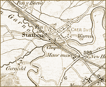
In a way the map on this page lets us see Caersws at two different years on the same map!
It is a small part of a larger map made by the surveyors of the Ordnance Survey in 1836 and was on sale in bookshops. When the railways opened in the late 1850s and 1860s the Ordnance Survey simply added the line to the earlier map.

 
  Caersws in 1836  
  The map shows us that transport links have always been imortant to Caersws. The village was first established in Roman times where two routes met and there was a crossing over the river. (You can see the outline of the Roman settlement just to the right of the railway on the map)
These two routes were - the road down the Severn valley, and the route up through the hills to the North West through Carno and on to the coast.
At the beginning of the reign of Queen Victoria these two routes had turnpike roads on them. (See the Llanidloes transport pages for more detail). From the middle of her reign they had railway lines built along them.


Caersws in 1903...

Back to Llanidloes map menu