Llanidloes
Victorian maps
  Caersws in 1903  
 

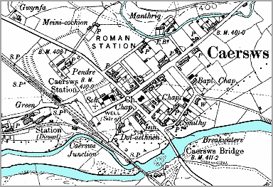
This map is a detail from a map produced in 1903 by the Ordnance Survey. It was made at a bigger scale and shows more detail.
This is how Caersws looked at the end of Queen Victoria's reign. If you compare this map with the map of Caersws in 1836 you will see the overall shape of the village has not changed greatly. There are some signs of change here though.

 
  6" map of Caesws in 1903  
  Besides the main railway line going off the the North West to the Welsh coast, you can also see a small railway going off to the West past a disused station. This was a small railway built especially to bring lead from the mines at Y Fan.
The place where the two railways meet is marked as Caersws Junction. These railways would employ clerks, porters, carters and signalmen.

The village now has a school (marked Sch on the map). This meant local children got an education and new possibilities when they grew up.
Besides the church there are three other chapels (Ch.) marked on the map. This shows that there was an increase in nonconformist people in the community who wanted to worship in their own way.


Caersws in 1836...

Back to Llanidloes map menu