| Census figures for Llangurig parish | ||
|
|
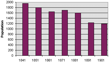
| The actual recorded figures for the population of the parish were:- | ||
| In
the year 1841 - 1951 people In the year 1851 - 1802 In the year 1861 - 1641 In the year 1871 - 1701 In the year 1881 - 1605 In the year 1891 - 1231 In the year 1901 - 1191 |
||
| The parish
of Llangurig covers a huge area of upland as well as the upper Wye. It also
includes Cwm Belan which had a flannel mill
in Victorian times. Compare the graph above with those for Trefeglwys, Carno
and Llandinam. Are the overall trends the same? What was happening in the area in the 1860s which might have caused the population to rise? Why do you think the population declined at the end of the period? |
|
Back to Llanidloes population menu
|
||