Llanidloes
Victorian maps
  Llangurig in 1866  
 

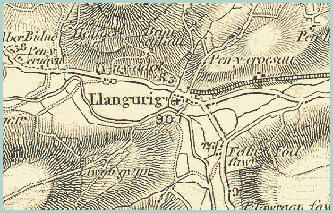
The map below shows a detail from an Ordnance Survey map of 1866. Although this one of the more remote communities in Victorian Montgomeryshire it does have an important site in terms of communications. Like Caersws it is situated where two routes meet and a bridge crosses the River Wye.
Right across the middle of the map is the turnpike road from Llanidloes which crosses the mountains to the coast at Aberystwyth. Coming South from the village of Llangurig is the turnpike road south to Rhayader.

 
  OS map of Llangurig in 1866  
  The T.G. marked on the map is the tollgate where travellers would have to stop to pay their tolls if they wanted to use the road. This is the tollgate which was attacked by the Daughters of Rebecca. (See Llanidloes Transport pages)The railway builders of the Victorian period had grand plans to cover the nation with railways. They mostly achieved this but sometimes their plans were too ambitious or unrealistic.
Plans were made to build a railway westward through Llangurig to the coast. This would have been very expensive to build and would never have been used enough to cover the cost. Only a small part of this route was constructed.
On the map above you can see the line as far as Llangurig. By the end of Queen Victoria's reign this had been abandoned.


Llangurig in 1903...

Back to Llanidloes map menu