Llanidloes
Victorian maps
  Llanidloes in 1903  
 

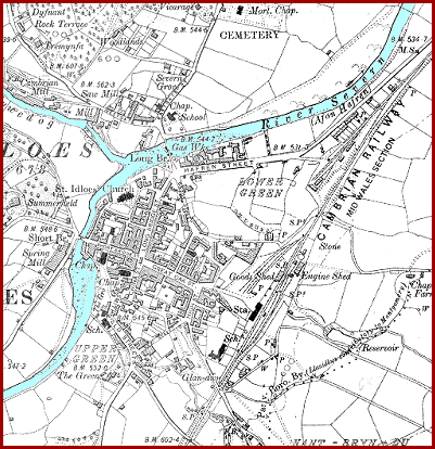
This is a detail from an Ordnance Survey map of 1903 and shows the town at the end of Queen Victoria's reign. Although this has a lot more detail than the 1836 map we can still learn a lot by comparing the two.
The basic layout of the town is still the same as it was in 1836, but there are a lot more houses and buildings. By 1903 the town is connected to the outside world with a railway line. This means things made locally can be sold further away and local people can get a wider range of goods in the shops. The possibility of travel has reached ordinary people.

 
  6" map of Llanidloes in 1903  
  There are now three schools on the map offering local children an education.
In 1836 there were many weavers in Llanidloes but most of them were handloom weavers working in their own homes or in small workshops. By 1903 there are large woollen mills over the Short Bridge from the town and on the banks of the Clywedog. These factories could produce far more cloth on powered looms.
By the end of Queen Victoria's reign, though, the flannel industry is in decline. (See the pages on the Flannel industry for more information.)
On the banks of the River Severn by the Long Bridge there is a Gas Works (marked Gas Wks.). This made coal gas by heating coal. The gas was then used for street lighting and piped into homes for lighting and cooking.


Llanidloes in 1836...

Back to Llanidloes map menu