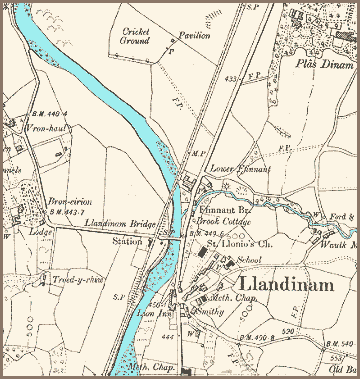
The map below is a detailed Ordnance Survey map made in 1903. It gives us a picture of the community around the end of Queen Victoria's reign, and we can see that there have been some changes in the area.

| Llandinam in 1903 | ||
|
The map below is a detailed Ordnance Survey map made in 1903. It gives us a picture of the community around the end of Queen Victoria's reign, and we can see that there have been some changes in the area. |
||
 |
| Firstly
we can see that a large new estate has been established with two new grand
houses standing in their own grounds. To the North of the village we can see Plas Dinam has been built as the seat of the Davies family. Similarly Bron Eirian has been built on the west bank of the river. David Davies was a local man who made a fortune building railways and establishing coalmines in South Wales. With this wealth the Llandinam estate was established and the properties built. In the later Victorian period many local people would work on the Davies estate or as servants in the great houses . The village itself has two Methodist chapels and a school. The Davies family were well known supporters of education and often allowed their grounds to be used for games and activities where school children could come together. (See the Llanidloes Schools pages). |
||
|
|
||