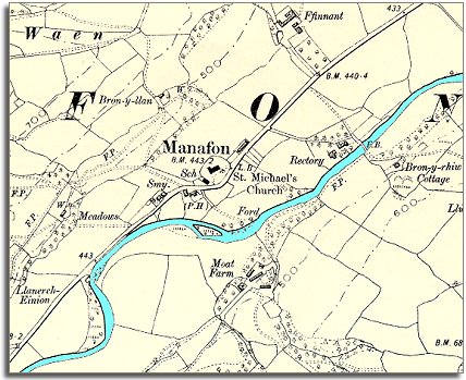
The map below is an enlarged detail of an Ordnance Survey map made at a scale of 6 inches = 1 mile in 1902. It allows us to look in a bit more detail at the community at the end of Queen Victoria's reign.
| Manafon in 1902 | ||
|
The map below is an enlarged detail of an Ordnance Survey map made at a scale of 6 inches = 1 mile in 1902. It allows us to look in a bit more detail at the community at the end of Queen Victoria's reign. |
||
|
||
| The first thing to notice is that the community has not changed dramatically since 1836. The centuries-old ford has not been replaced by a bridge but there is a footbridge by the rectory. Tiny though the hamlet is Manafon does have a smithy (marked Smy.)and a village pub (marked P.H.). | ||
 More
important to the changes in life in Victoria's reign was the village
school (marked Sch.) which we can see by the church
(shown here). Just as in Castle Caereinion and other rural settlements in
the area the new school offered children from the poorest families more
opportunities when they grew up. Instead of having no possibility of a life
anywhere but working on the land, children were given enough education to
enable some of them to do something different with their lives. More
important to the changes in life in Victoria's reign was the village
school (marked Sch.) which we can see by the church
(shown here). Just as in Castle Caereinion and other rural settlements in
the area the new school offered children from the poorest families more
opportunities when they grew up. Instead of having no possibility of a life
anywhere but working on the land, children were given enough education to
enable some of them to do something different with their lives. |
||
| Compare with Manafon in 1836 |