Llanfair and district
Victorian maps
  Llanllugan in 1836  
 

The map below is an enlarged section of an Ordnance Survey map made at a scale of 1 inch = 1 mile in 1836. Although it is not very detailed it does give us an idea of the area in the early Victorian period.
The way the map is shaded gives us a very good idea of the shape of the landscape. From this you can see Llanllugan beneath the ridge of Cefn Coch to the North.
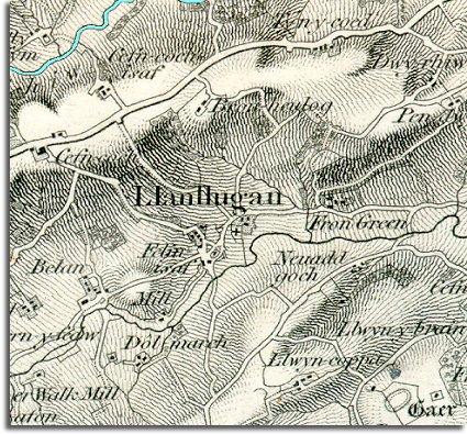
 
  map of Llanllugan in 1836
  The shading shows this to be an area of upland farms, and earning a living on this landscape must have been hard in Victorian times. Most of the inhabitants would have been involved in farming in some way.  
  Notice that the map shows a mill and walkmill using the power of the river and also Felin isaf near the church. The walkmill will have been a fulling mill where fullers earth is pounded into woven cloth to clean it and tighten up the weave, and the other mills must have provided a useful service grinding local grain into flour.  
  The oval enclosure in the bottom right hand corner (marked Gaer) shows us that 2000 years before Victorian times people were farming and defending these hills.  
  Compare with Llanllugan in 1902  
 

Back to the Llanfair maps menu

Back to top
Go to Llanfair Caereinion menu